DFRobot
RPLIDAR A2 - 360 Degree Laser Scanner Development Kit
All Products
Distance & Ranging Sensors
New Arrivals
Robotics
Sensors
Brands and Manufacturers
Robotics & Motion
Sensors & Modules
Sensors & Input
Robotics
Prototyping & Wiring
Little Bird Electronics
$1,136.85
|
In stock at supplier
RPLIDAR A2 is the next generation low cost 360 degree 2D laser scanner (LIDAR) solution developed by SLAMTEC. It can take up to 4000 samples of laser rang...
Get notified when back in stock
Estimated Delivery
Arrives
Disclaimer
Secure checkout
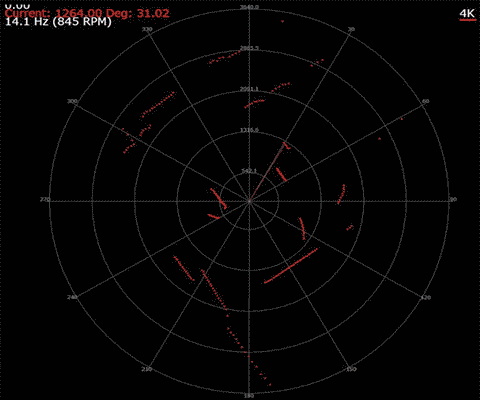
RPLIDAR A2 is the next generation low cost 360 degree 2D laser scanner (LIDAR) solution developed by SLAMTEC. It can take up to 4000 samples of laser ranging per second with high rotation speed. And equipped with SLAMTEC patented OPTMAG technology, it breakouts the life limitation of traditional LIDAR system so as to work stably for a long time. The system can perform 2D 360-degree scan within a 8-meter range. The generated 2D point cloud data can be used in mapping, localization and object/environment modeling. The typical scanning frequency of the RPLIDAR A2 is 10hz (600rpm). Under this condition, the resolution will be 0.9°. And the actual scanning frequency can be freely adjusted within the 5-15hz range according to the requirements of users. 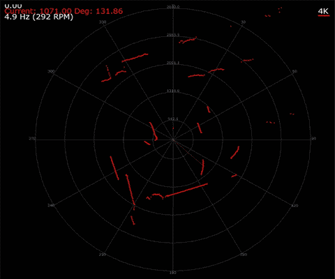
 The RPLIDAR A2 adopts the low cost laser triangulation measurement system developed by SLAMTEC, which makes the RPLIDAR A2 has excellent performance in all kinds of indoor environment and outdoor environment without direct sunlight exposure. Meanwhile, before leaving the factory, every RPLIDAR A2 has passed the strict testing to ensure the laser output power meet the standards of FDA Class I.
APPLICATIONS
SPECIFICATIONS
DOCUMENTS
SHIPPING LIST
RPLIDAR A2 Compared To Former Model
The RPLIDAR A2 adopts the low cost laser triangulation measurement system developed by SLAMTEC, which makes the RPLIDAR A2 has excellent performance in all kinds of indoor environment and outdoor environment without direct sunlight exposure. Meanwhile, before leaving the factory, every RPLIDAR A2 has passed the strict testing to ensure the laser output power meet the standards of FDA Class I. Note: The newest Rplidar is A2M8, which detecting range has been improved to 8 meter
APPLICATIONS
- Obstacle Avoidance
- Autonomous Mapping
- Route Planning
- Navigation
SPECIFICATIONS
- Model: RPLDIAR-A2
- Distance Range: 0.15 - 8 m
- Angular Range: 0-360 degree
- Distance Resolution: <0.5 (0.15~1.5 meters)
- <1% of the distance (All distance range)
- Angular Resolution: 0.9degree
- Sample Duration: 0.25 millisecond
- Sample Frequency 4000Hz
- Scan Rate: 10Hz
- Weight: 340g
DOCUMENTS
SHIPPING LIST
- RPLIDAR A2 - 360 Degree Laser Range Scanner x1
Jargon buster
Plain-language definitions for the technical terms used above.
- LiDAR
- A sensing method that uses laser light to measure distance and build a 3D picture of the surroundings. It matters for robotics and autonomous systems because LiDAR data can help with mapping, navigation and obstacle detection.
Find this product in
Sensors & Input
Supplier page — dfrobot.com
Supplier Description · 423.8 KB · Click any page to view full size
Related Tutorials
Free guides on learn.littlebird.com.au